

Mark Boyle who was born in Glasgow, collaborated with his partner Joan Hills during the 1960s. Their project ‘Journey to the surface of the Earth’ began in 1968 – 69. After being blindfolded, they threw darts at a world map, in order to pinpoint 1,000 areas of the earth’s surface to duplicate. When travelling to a selected site, the Boyles would throw a T-square in the air to select a random area to replicate. In the 1970s their two children assisted in producing these works. Together they operated under the name ‘Boyle Family’.
Image Analysis
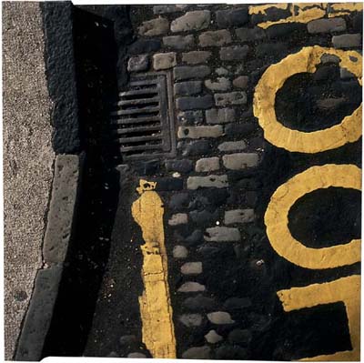
This photograph depicts a street corner and a road with yellow markings and different textures of tarmac and cobbles. The image shows exactly what you would see if you looked down onto an area of road and because of this I think the image was taken handheld due to the angle that is shown through the photograph. The colours of the photograph are typical and natural, along with the shadows and lighting created by the natural light. The road looks like it’s damaged and decaying which shows the viewer what you can find by simply looking at places that are usually overlooked. The photograph doesn’t have much depth, except for the curb but even this appears to be on the same level as the road, possibly because of the bird eye view style of the shot. The photograph reflects the time period, with a new style of making roads. The tarmac covering the cobbles shows the advancement in society as well as the destruction of the pattern. The photograph gives a profound sense of reality since the image is so simple yet effective since it displays the view that everyone would be able to see on a day to day basis, but would never look at twice.