Gaul was a region of Western Europe during the Iron Age that was inhabited by Celtic tribes this included jersey. The area which we now call St Helier was first used as a fishing village on the dunes between the marshy land behind and the high-water mark. The parish church was built on the water front in the 12th century where boats were tied to the walls surrounding it, now due to the reclaimed land sits a lot further in land. Elizabeth Castle was built in the early 1600’s due to Mont Orgueil no longer being sufficient for the cannons being used to defend the island and town.
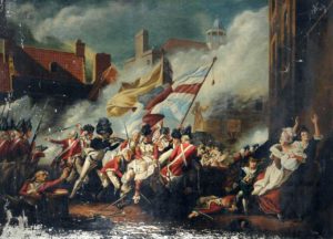
18th Century: The town consisted of mainly houses, shops and warehouses along the coast and surrounding the church and market (Royal square from 1751). £200 was given by George II towards the construction of a new harbour, before this boats beached themselves on a low tide and good were transported over the beaches to hard land. In 1781 the royal square was home to The Battle of Jersey, a scene from this event is captured in the famous painting by John Singleton Copley‘s
Copley, John Singleton; The Battle of Jersey; Victoria College, Jersey; http://www.artuk.org/artworks/the-battle-of-jersey-137676
19th Century: Roads built for military purposes made it possible for farmers to transport their goods from farms to the fast sailing ships and later steamships in St. Helier and then on to Paris and London, this was the start of Jersey’s success in agriculture. In 1820 there was an increase in english speaking people moving to live in Jersey due to the end of the conflict with France, better communication and transport. During the second half of the 19th century roads were widened to allow trucks filled with produces to access the harbour, many ancient buildings were demolished in the town centre for this. Very few building remain in St. Helier from before the 19th century giving the town a victorian character.
20th Century: A tunnel road was built under Fort Regent in the 1960s allowing traffic to avoid the steep hill from the east side of town around the harbour. at this time fort regent was also in the 1960s, income from the developed into a leisure facility which had a cable car to connect it to the town centre. King Street was made into a pedestrian friendly road in the 1970’s as more high street shops moved to the island. Fort Regent leisure centre was later closed in the 90’s.